Virginia Senate Passes Police Reform Package That Would Ban No-Knock Warrants
Tropical Depression 19 is bringing heavy rain and gusty winds to Florida Saturday before the storm is expected to intensify as it moves into the Gulf of Mexico later in the day.
Flood watches are in effect through Sunday for areas of Florida’s west coast including Tampa, Bradenton, Port Charlotte, and Fort Myers. In these areas, 2 to 4 inches of rain is expected through the weekend.
According to the National Hurricane Center (NHC) Tropical Depression 19 is expected to become a named tropical storm over the Gulf of Mexico today. The next name on the list is Sally.
Most forecast models have the system moving toward the northern Gulf Coast and likely making landfall somewhere between New Orleans and Panama City by late Monday or Tuesday, however if the track shifts farther west or slows down, landfall may hold off until Wednesday.
“The depression is forecast to strengthen to a hurricane early next week as it moves across the northeastern Gulf of Mexico, and there is an increasing risk of life-threatening storm surge and dangerous hurricane-force winds from southeastern Louisiana to the Alabama coast,” according to the NHC.
Once it reaches that area of the Gulf Coast the steering patterns break down and the system meanders near the coast.
Whether the meandering is offshore prior to landfall or onshore will not make much of a difference in terms of rainfall. In either case, because of the slow forward movement along the Gulf Coast significant flooding is possible.
As of right now, widespread rainfall accumulations of 4 to 6 inches are likely. However, there will be isolated areas right along the coast that could pick up more than a foot of rain.
Already an Active Season
So far this season, we have seen 17 named storms. The average for an entire season is 12. Early in the season, forecasters called for a very active season.
Many storms broke records for being the earliest named to date, including Cristobal was the earliest named “C” letter storm in recorded history and Hanna was the earliest “H” letter storm. All but three named storms (Arthur, Bertha, and Dolly) set records for being the earliest named storm for their respective letter.
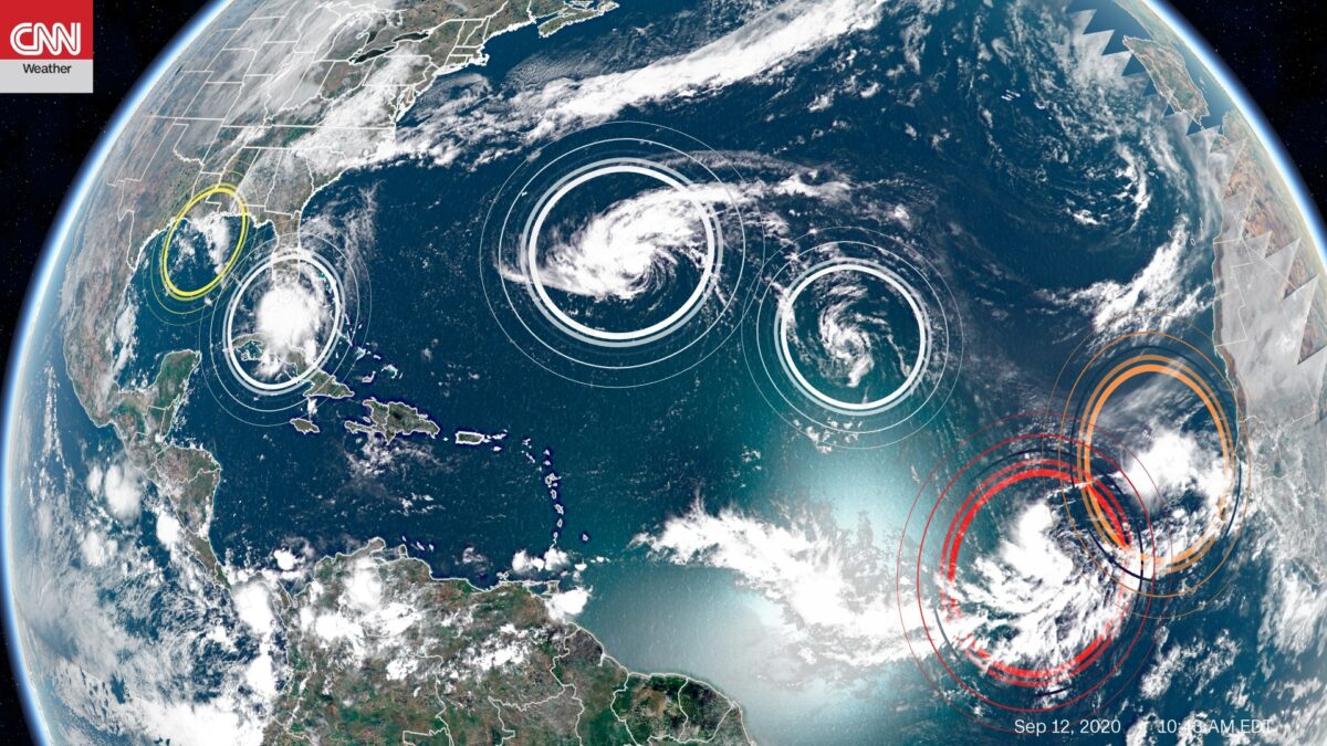
The system crossing over Florida is just one of several systems in the Atlantic. The NHC is currently watching six areas: 2 tropical storms, 1 tropical depression, and 3 tropical disturbances. Thursday marked the peak of the Atlantic hurricane season.
Tropical Storm Paulette is forecast to strengthen into a hurricane today. Paulette is forecast to track towards Bermuda and potentially make landfall early Monday morning as a category 2 storm. A hurricane watch is in effect for Bermuda with hurricane conditions possible within 48 hours. Tropical storm conditions will begin to impact Bermuda by Sunday afternoon and hurricane conditions will begin Sunday night.
Another system to watch is a broad area of low pressure southwest of the Cape Verde islands. This system has a 90 percent chance of development over the next five days. The National Hurricane Center expects a tropical depression to form within the next couple of days. After Sally, there are only three names left on this year’s official list: Teddy, Vicky, and Wilfred. After that the NHC will move on to using the Greek alphabet.
La Niña is Officially Here
On Thursday the National Oceanic and Atmospheric Administration announced they are issuing a La Niña Advisory, meaning La Niña conditions are present in the central and eastern Pacific Ocean.
In a typical El Niño phase, much of the Pacific Ocean is characterized by warmer waters, whereas La Niña features a cooling of those same Pacific waters. In the case of hurricanes, La Niña weakens high atmospheric winds, which allows warm air pockets to grow vertically and develop into hurricanes.
The-CNN-Wire
™ & © 2020 Cable News Network, Inc., a WarnerMedia Company. All rights reserved.
Focus News: Tropical Storm Sally Could Form in the Gulf of Mexico Today
DHS Acting Secretary Chad Wolf Subpoenaed by House Democrats