Strong winds and flooding are causing what the National Weather Service described as “significant impacts” in parts of Alaska’s western coast on Saturday as a “powerful and significant” storm threatens the region.
The National Weather Service (NWS) has imposed coastal flood warnings from parts of southwest Alaska all the way up to the Chukchi Sea coast in northwest Alaska, warning further that elevated water levels will likely be slow to recede.
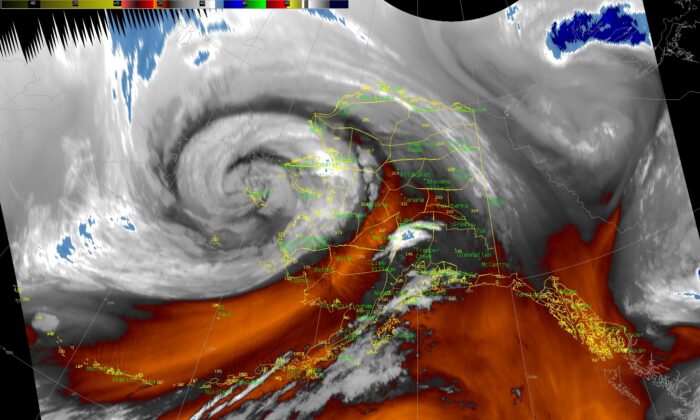
The storm, which is a remnant of Typhoon Merbok, is “powerful and significant in every stretch of the imagination,” NWS Fairbanks said in a statement early Saturday.
In an advisory, the NWS said the storm will bring “potentially historical coastal flooding, high surf, coastal erosion, high winds, high seas and heavy rain to western Alaska and the Bering Sea.”
The agency warned that water levels in Nome could be up to 11 feet above the normal high tide line, and in Golovin up to 13 feet.
As of early Saturday, the water level at Unalakleet was over 11 feet and was forecast to peak at around 15 feet later in the day.
“This will likely be one of the largest peaks on record,” NWS Alaska Region said in a statement.
The storm was moving north through the Bering Strait early Saturday and was slowing down in speed, which won’t let high water levels recede quickly after they peak, according to NWS Alaska Region.
Here’s a surface analysis from 4pm Fri and expected location, moving north through the Bering Strait, by 4pm Sat. It’s also slowing down in speed as expected, which wont let high water levels come down quickly after they peak. We’ll be tracking this all weekend. pic.twitter.com/OQYsFJpDj6
— NWS Alaska Region (@NWSAlaska) September 17, 2022
Reports have come in that water has been rising quickly in Golovin, and that by early Saturday an old runway was almost completely submerged.
“Water continues to rise and will be rising throughout the night. Significant impacts are likely to continue. Stay safe,” NWS Fairbanks said.
Seas at Nome were building on Friday, according to Rick Thoman, an expert at the Alaska Center for Climate Assessment and Policy (ACCAP).
Nome saw winds as high as 59 mph at Nome and 55 mph at Golovin, according to Thoman.
As of early Saturday, the tidal surge was already underway at Nome and Red Dog, according to NWS Alaska Region.
“Water levels will continue to rise at both locations, reaching a peak this afternoon at Nome, while Red Dog isn’t expected to peak until early Sunday morning,” NWS Alaska Region said.
NWS Anchorage reported that strong winds hammered the Kuskokwim Delta late Friday, with gusts 65–75 mph. By 5 a.m. local time on Saturday, gusts slowed to 50–60 mph.
“Winds will remain gusty through the afternoon before diminishing this evening,” NWS Anchorage said.
Alaska’s division of Homeland Security and Emergency Management said local agencies were preparing to respond to the impacts of the storm.
“Local, state, federal, tribal, and non-government emergency response and recovery agencies are preparing to deploy their capabilities,” the agency said in a statement early Saturday, adding that there were no reports of damage at the time.
Authorities warned residents affected by the storm not to go anywhere near flooded areas.
“Remember, turn around, don’t drown. It only takes 6” to sweep you off your feet,” NWS Fairbanks warned in a statement.
The last time Alaska was hit by a destructive storm system was in 2011, when an extratropical storm much like the current remnant of Typhoon Merbok hammered parts of the state, causing significant damage from driving rain, strong winds, and flooding.